This is it! I am a regular at “AT” crowd now.
After 5AM – wake up very early as youngsters around me must get their early start.
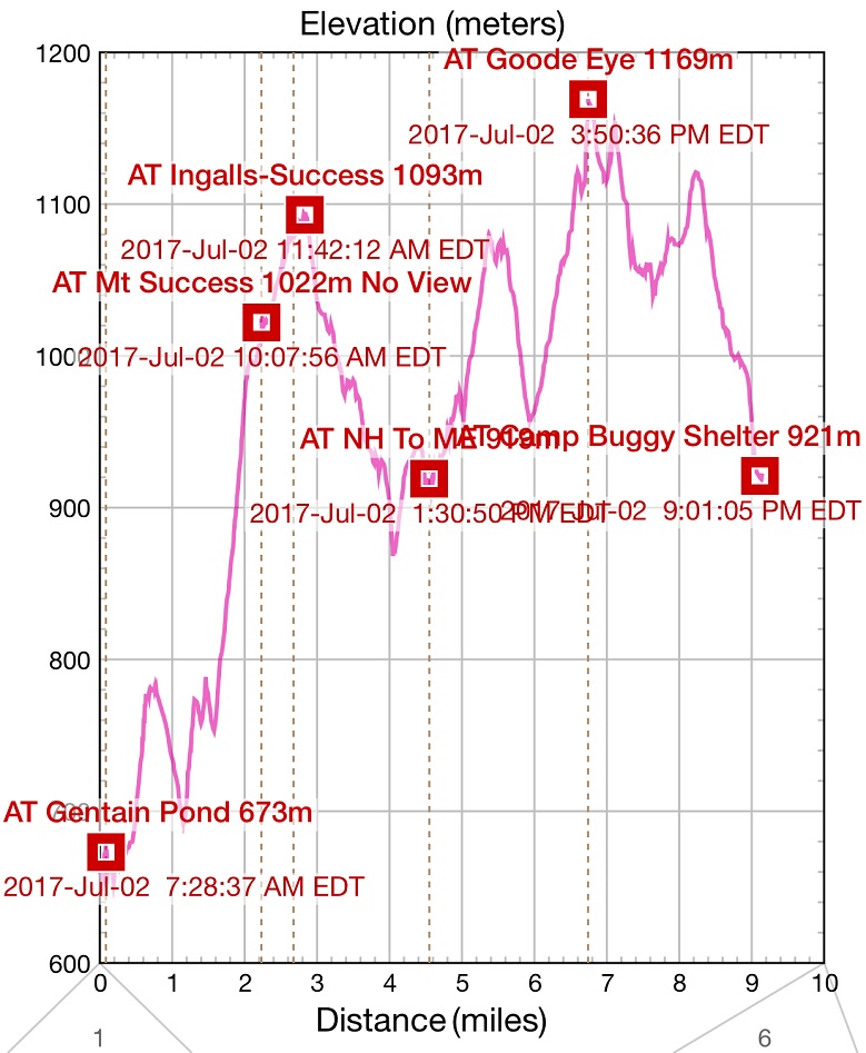
06:48 -trip around the shelter environs with a camera. Shelter was built in 1974 – 43 years ago, but it is still younger than me.
07:32 – start tracking my progress on iHikeGPS App
| IMAGE 01 | IMAGE 02 |
| TEXT 01 | TEXT 02 |
08:06 first peak of the day climbed. Now few minutes to the bottom of the ravine.
09:09 – 09:23 Stop for rest, smell the roses and for the morning abolitions. I did not turn off the GPS tracking, and on the elevation chart, this stop shows as a small dive in altitude. Pictures show a rather steep elevation grade. In reconstructing trip details, it is interesting that stops are often more memorable than hike itself.
| IMAGE 01 | IMAGE 02 | IMAGE 03 |
| TEXT 01 | TEXT 02 | TEXT 03 |
Trail conditions are as much the same as yesterday – muddy, wet, and lots of exposed rock that presents a constant danger of slip and fall.
10:06 – complete first 2 miles today and climb to an unnamed local mount (3,364′ or 1,022 m). Mt. Success is somewhere very close.
Right after fist intermediate summit, trail gets into open space with very little vegetation, strong winds and very wet bogs with puncheons.
10:42 – 11:32 -Here on the windy rocks I took another rest stop for as it turned out to be 50 minutes. Wind is a good force to dry things, but when it is that strong, it rips things and takes them away from you.
11:38 – final real top of the Success mountain is reached (1,093 m or 3,565′). On the map, there is a word Ingalls next to Success Mountain. According to Wikipedia, that is how this mountain was called before 1936. Summit is so flat and so spread out that you think that you already there, but you are not there yet.
I did know about an unmarked trail leading to a site of a plane crash near Mt. Success, but in a rush of a mile crunching I completely forgot about it. Date of a plane crash 1954-11-30 and next time I will remember to search for it.
12:25 – 3.4 miles completed – This is last connecting trail before the border. Here I’ve met a day hike couple, right after I finally stepped on a floating wooden structure and completely submerge my right boot under the water. Let’s call them sweet lady and rude dude, because he would not step away from the path. This is an important couple, because miraculously I will meet them again in ME in the early hours of Tuesday, July 4 on my very last leg of the hike, and we’ll have a good laugh about these two random run ins into each other.
13:00 – I’ve completed 4 miles 5.5 hours – very, very slow pace. And I am planning to do 8 miles today?
13:28 The border. Completed 16.5 in NH, and there are 14.6 more to go in ME. Few yards before the border on NH side you’ll encounter a wooden ladder like of which you would see several more times in ME. NH/ME border is 4.5 horizontal miles from Gentain Pond Shelter.
| IMAGE 01 | IMAGE 02 | IMAGE 03 |
| TEXT 01 | TEXT 02 | TEXT 03 |
14:08 just passed a very challenging spot. The path between two boulders was so narrow, that I had to take my backpack off, and carry it high above my head to pass the path. This was the most challenging spot on the trail today. Who knows, what kind of challenges I will encounter tomorrow at Mahoosuc Notch?
14:11 I am at a junction to Carlo Col Shelter. Next shelter is 4.4 miles away. Can I do this today? I am already marching for 7 hours and made only 5 miles.
| IMAGE 01 | IMAGE 02 |
| TEXT 01 | TEXT 02 |
To speed things up I’ve decided to measure the distance covered every 15 minutes.
13:46 depart from the NH/ME border – 0 miles.
14:00 0.3 miles – this is 1.2 miles per hour pace.
14:15 0.5 miles due to a very difficult and narrow passage and I am climbing up now.
14:30 0.85 miles – this is a good pace, and down section begins.
14:45 1.2 miles – I am really pushing myself, and enjoy every flat or down step of the trail.
15:00 1.6 – well, almost 1.6 miles. Now trail turns straight up. No more easy going.
15:15 1.9 – I am slowing down.
15:27 I am almost spent, but something big and important is about to hit. For the first time, I see metal staples that help you to climb up and down.
15:30 2.2 miles – I am out of breath. Trail goes up almost vertically. When did it stop?
15:37 Here it is. This is the highest point so far – Mount Goose Eye – 1,169 m or 3,860′. I am settling here to rest and dry up as a couple of male hikers appear from opposite directions. We start to talk. They live in middle US states, but drove or flew here to Maine for holidays. They just do a quick dash from route 26 to the NH/ME border and back. One of the guys fell on a slippery slope of Mahoosuc Arm and hit his face and knee. Pretty dramatic if you ask me, but no one pays any attention to things like this when you do miles with a big rucksack on your back. They encourage me go complete remaining 2.6 miles to a campsite, as there are no good spots in between. Everyone out here supposed to have a trail name, and do not have one. From Russian “Udar Gromov” (thunder strike) they derive a new trail name for me – “Rolling Thunder”. Very fitting, I think. As, I am fast as a thunder, but very slow here on the trail. With their encouragement and a new energy from the Lara Bar I continue the hike.
16:07 – 17:58 – last 2.4 horizontal miles with 2 more peaks and a significant descend at the end. It was tough. Especially first mile. You can see the distance you covered, because trail goes over open terrain, but it seems endless. And much of the trail sits on puncheons – sturdy wooden trunks to keep your feet out of murky waters. On the elevation graph, you can see that horizontal miles measured by GPS are one thing and actual miles that you must march up and down are entirely different thing.
You might have a good intention to go safe and stay dry, but once again, it takes just one floating puncheon (attached logs that elevate trail) to step on, and your feet submerge completely under the water. Two guys at the top of Goose Eye Mountain warned me to be very careful with bypassing the mini-bogs on this stretch of the trail. They saw hikers going waist-deep under the water trying to march around the bogs. These deep, hidden by vegetation pockets are especially prevalent on top of the flat mounts where water has nowhere to go. In one case, normal path using logs was unacceptable as it was leading directly into a deep pool of water. Hikers were seeking ways around it. But both left and right detours where very bad and unsafe. I choose to go to the right making my way holding to branches of a bush or stepping on these branches for support. Once again, hundreds of yards of this section of the trail are equipped with sturdy convenient logs (sometimes even to excess), but there are still places that are challenging not because they are steep, but precisely because they are flat and watery.
| IMAGE 01 | IMAGE 02 | IMAGE 03 |
| TEXT 01 | TEXT 02 | TEXT 03 |
16:24 – 0.35 miles -first local peek is reached and it still can be considered as a part of Goose Eye. Both peaks are bald enough to be visible from each other’s tops. Now, I begin to meet groups of people who are dreaming of reaching Carlo Col Shelter this evening, and for me it seems super challenging because of the sheer distance. First, it is a young Indian couple, then a group of 4 youngsters headed by a very determined leader with a momentous knife attached to a strap of his backpack. And finally, I’ve met what seemed like a son and father duo, and son was all determined to reach Carlo Col Shelter before day expires today. And father was all silent and may be doubting the challenge. But those are the vivid portraits on the trail. These people must go forward and forward, up and down with heavy packs, regardless of fatigue and wet feet. Just like me.
16:57 – 1 mile only – I can see the top where I started 50 minutes ago. It looks so far. Was it really just one mile?
17:14 – 1.5 miles – I am on top of a North Peak. At the time, I did not notice any pronounced mountain top while marching. Only now looking at the chart I can see that this was the last climb before descent to a shelter.
| IMAGE 01 | IMAGE 02 |
| TEXT 01 | TEXT 02 |
17:58 – 2.4 horizontal miles – I am at the Full Goose Shelter. Here I see one of the guys from Gentain Pond Shelter. Here reached here probably several hours before me. Shelter is a very long multi-section construction, and people inside will be must be victims of bug-attacks. There are plenty of available spaces both in shelter and on platforms. After a brief look around, I decided to skip the shelter today and sleep on a platform in my hammock serving as a giant bug net. I picked a site that has trees around the planform, so I will be 50% suspended in the air and 50% lodged on the flat floor of the platform. I can tell you right now that this turned out to be a very comfortable accommodation. Your head is elevated just enough so that you do not need a pillow, but most of your torso is securely on the clean, dry platform, so there is no swaying, and all the things you need are within reach on the platform. Ideal use of available resources.
Water source is a nearby brook, but water color is yellowish.
19:00 Food at the tent platform: vegan Backpacker’s Pantry Cuban Coconut Beans and Rice (960 calories) – very good, but sodium very high – 810 mg. To boil one liter of water (~34 oz.) I had to fill stove with fuel twice. Not a big deal. When boiling is done, I can pour unused alcohol back into the bottle.
 |
 |
| Day summary: 9 miles total hike. About 9 miles left till finish line on route 26. | Number of hikers met on the trail today – 19. (Not counting people at the shelters) |
Tomorrow morning, I will hit famous Mahoosuc Notch.
21:18 – 22:00 – write daily notes inside hammock away from bugs
Navigate through the List
- Preparations for July 2017 trip to Appalachian Trail (AT) (2017/06/29)
- 2017/06/30 Friday - Who covers license plate with a Panama Hat? (2017/06/30)
- 2017/07/01 Saturday - Gift of shelter at the end (2017/07/01)
- 2017/07/02 Sunday - One of them now (2017/07/02)
- 2017/07/03 Monday - Endless Mahoosuc day with 7 miles (2017/07/03)
- 2017-07-04 Tuesday - From hike to bike, to car, to home (2017/07/04)
Be the first to comment