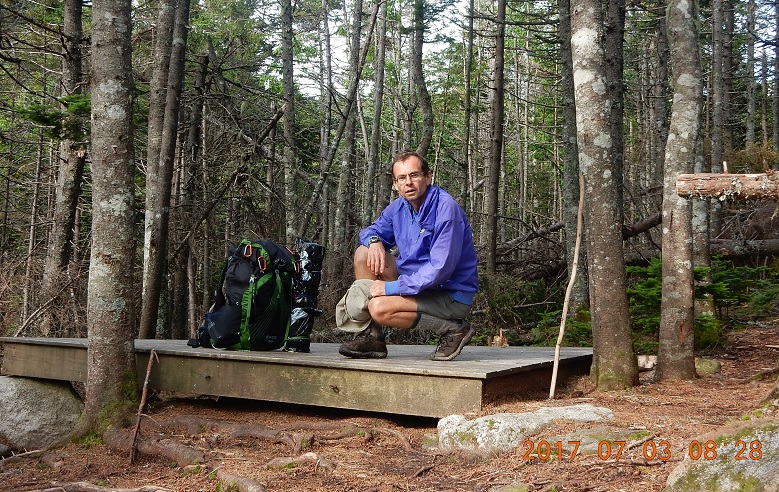
I slept very well on my tent platform in a hammock and woke up around 7 AM. I folded all my things without ever leaving the platform. I had plenty of filtered water from yesterday for drinking and cleaning.
 |
 |
| 08:26 I made more pictures on platform, but hammock was already folded at this point. Believe me – it was a comfortable setting. | Plan for today: Mahoosuc Notch plus reaching the highest elevation of the trip |
08:31 – I congratulate Lira on her day number 10 at assisted fasting spa – Centre Val Santé – in Rawdon, Canada. She is there for long 22 days from Saturday June 24 till Saturday, July 15.
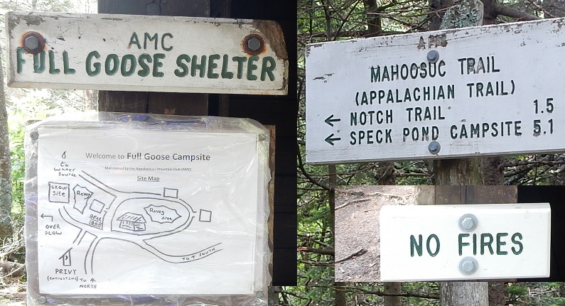
08:36 – departing Fool Goose Shelter and start the hike towards South Peak and Mahoosuc Notch
Weather is beautiful. Trail goes up for next 30 minutes.
 |
 |
 |
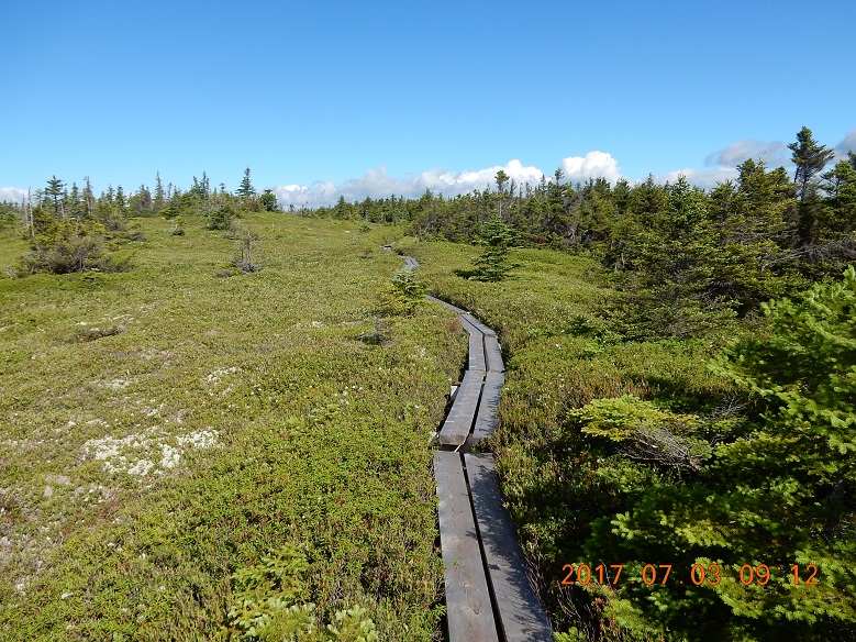
| 09:12 – South Peak – learn a new word – puncheon – it is like a mini-bridge | 09:06 – South Peak – it is a large flat area with windy open spaces, wide views and bog passages covered by a series of puncheons. | 09:12 – South Peak – human feet free the surface from vegetation and eventually you get a stone path |
 |
 |
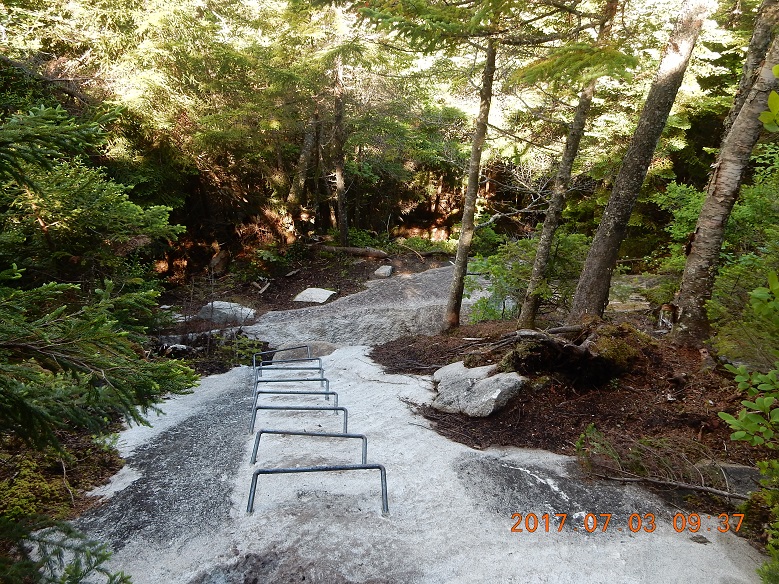
| 08:41 – 10:08 Mile and a half of contemplative approach to Mahoosuc Notch | 08:41 – 10:08 To reach Mahoosuc Notch trail dives down into a ravine |
 |
 |
| 09:37 – descent getting steep so trail uses series of metal staples for safety. For the sake of Mahoosuc Notch section, trail descends deep into ravine instead of going on top of the range as it usually does. So, with each step down you know you would have to pay the price of climbing out of ravine on the other end of the Notch. | Descent is steep enough so that you can see far far down the valley. I do not remember taking this picture. All senses are focused on caution and trying to reach the Notch without slip and fall. |
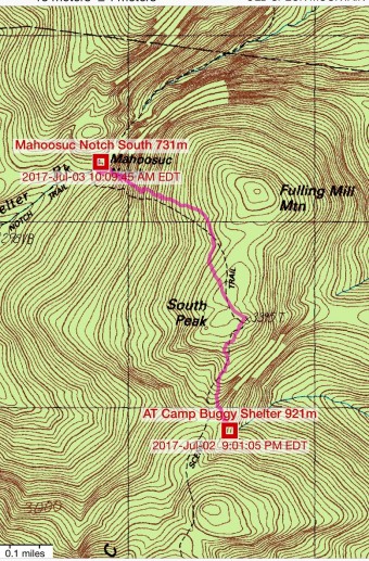
10:05 – first 1.5 horizontal miles are behind me – junction with local trail to Success Pond Road and beginning of Mahoosuc Notch. It is more interesting to hit the Notch in the beginning of the day when all your senses are still open for new impressions.
10:15 – start traversing the Notch from South end. Old packed snow is visible in deep chasms between boulders and temperature is considerably lower. Wind gusts feel as if you open refrigerator on a hot day.
| IMAGE 01 | 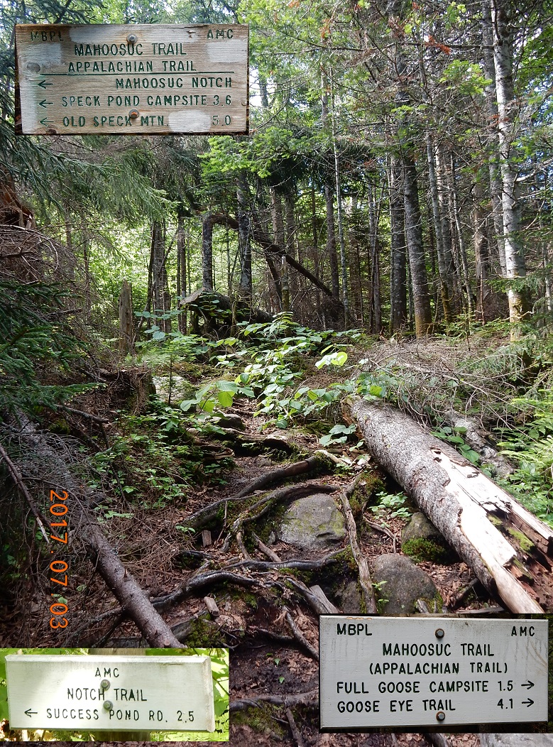 |
IMAGE 03 |
| TEXT 01 | TEXT 02 | TEXT 03 |
10:28 – path is going on the bottom of a narrow notch – steep vertical stone walls on both sides. Surprisingly, there is no running water at the bottom. That is why all the show stayed intact. Boulders are large and require effort to advance.
10:49 – 11:06 first break after just 0.2 in the canyon. The spot for a break is very good. High on a series of boulders that are blocking the way anyway. Apply sun screen. Eat trail mix, first half of Lara Bar and yellowish water from the camp.
11:39 meet first hiker today – an ancient gentleman with 2 mighty highly decorated sticks. Few dozen steps behind him someone dropped folded 16 oz. Sawyer squeeze container. I yell into the wind – maybe he will hear – by my words die down.
| IMAGE 01 | IMAGE 02 | IMAGE 03 |
| TEXT 01 | TEXT 02 | TEXT 03 |
Right after that, two gringos from yesterday Goose Eye mountain caught up with me. They already covered many miles today from Carlo Col Shelter and they wanted to complete their hike today at route 26 where they started yesterday? Or couple of days ago? The same story here: I am falling behind on flat sections, but quickly catching up when trial goes down.
11:54 every time trail goes under boulders, I am find an easier way over the boulders. That way, I do not have to take off my backpack.
| IMAGE 01 | IMAGE 02 |
| TEXT 01 | TEXT 02 |
I even managed to get ahead of them and they stayed behind to have lunch at unofficial camp site where trail leaves the gorge and begins climb on the other side on the slope.
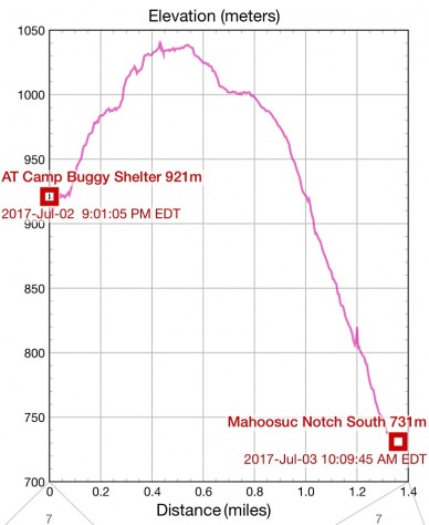
12:16 Mahoosuc Notch is over. Let’s the climb begin. This climb will lead to the highest point of the whole trip – Mahoosuc Arm.
12:49 – 13:49 clean water break and bath. It was a small spring that anyone can simply step over, but it formed a small knee-high waterfall here. And it is just a few yards away from the trail. This water was cold and crystal clear. Few steps up the trail was a river crossing with enough clearing to catch warmth of the sun. I used this opportunity to bathe and cool off. Water was cold and shallow, but it couldn’t stop me. I put on my bright orange trucks, so I didn’t have to watch out for unexpected AT hikers going to and from Mahoosuc Notch. I hang everything out to dry on sun-covered stones. Here I saw my two guys from yesterday and today (trail names Moose and Squirrel). At this point they were going fast and determined without regard for water or other obstacles. They were in the mood to finish the hike at a reasonable hour today. I will reach the parking lot on route 26 only tomorrow at 9AM.
13:51 I started to hike again. Usually, you do not know it in advance when you start a difficult section. This ascend turned out to be the hardest and highest. It was not very long – only 1 hour and 25 minutes, but I was climbing up for very long, long imaginary time. I even started to ask passersby how far till anything new? How far till the summit? How far till the shelter? And when this climb will end.
| IMAGE 01 | IMAGE 02 |
| TEXT 01 | TEXT 02 |
On this section, I’ve met solitary through hiker with music blaring. It is funny that people are trying to be here to get out of normal routine, but some must carry their safety blanket – loud rhythmic music in this case. I’ve met a father with three daughters and one son, all dressed in old-fashioned long dresses covering then from head to toe. They looked very disapprovingly (or enviously) at my shorty shorts.
| IMAGE 01 | IMAGE 02 | IMAGE 03 |
| TEXT 01 | TEXT 02 | TEXT 03 |
15:09 Trail begins to escape the clutches of the forest. First real views start to appear. Here I’ve met 2 girls and a guy with British accent. They made me turn my head, and I’ve noticed the opening vistas behind me. We discussed at length various typical Mahoosuc Notch matters and parted as friends.
15:15 Victory! I am on top of Mahoosuc Arm – 1,151m. Only 0.9 miles to the shelter. I will be skipping this shelter anyway, but this is one more milestone on my 31 miles hike.. Here I met a guy from Texas with a huge hat and sandals instead of boots. In Texas, they called chacos. He injured and severed his nail on a big toe and simply taped it over with duct tape. His trail name was Gringo (white mail), and he was catching up to British trio. Good people are energizing each other on the trail. With a new picked up energy, I decided to go on right away. Timid Speck Pond Trail branches off here. I’ve noticed it but did not pay any attention to it. I did not know for sure, where this trail leads to, except for a vague look at the map several hours earlier. Looking now, on the map this trail seems a shorter alternative (0.8 miles) down to the shelter.
This section was a “guilty” slide down again before final climb to Speck Mt.
15:46 Very soon I’ve reached multiple access points to the waters of Speck Pond and trail begin to go around the pond approaching the shore and then jumping away from it as if frightened. This jumping up and down occurs here at almost regular intervals.
15:56 – finally I’ve reached a junction with Speck Pond Trail again. It branched off earlier on top of Mahoosuc Arm. This trail would bring you to the shelter. But I am not staying at the shelter today. Instead, I took the path toward route 26. So far today, I already competed 4.5 miles and I was hoping to cover another 2 miles today to be closer to the parking lot (and the hidden bike) tomorrow morning.
| IMAGE 01 | IMAGE 02 |
| TEXT 01 | TEXT 02 |
16:01 – 17:18 – next 1 mile took me 1H and 20 min to complete. It is mostly up. If trail goes down, it muddles into wet spots. If trail goes up, it pops up into open unprotected boulders with strong wind gusts.
Here, inside on one the endless “V” shaped trail ups and downs, I’ve met one of the last hikers today. He was about 40-50 years old. He decided that he liked hiking now and apparently bought everything brand new, or it was a massive anniversary gift from loved ones. And now, all this brand-new shines and colors were dumped right on the ground. He was resting. I did not get any positive energy from this encounter.
17:19 – 17:35 Almost Speck Mountain – 1,238m – This is the highest point of this trip. When I reach a junction to go to the Speck summit 0.2 miles away, I did not even have energy to be exited. I took a brief rest to notify Lira and even answered some holiday soccer schedule questions.
17:35 – 18:48 descend to find water and to camp. According to a trail sign I already covered 1.4 miles out of 4.6 to a coveted parking lot. Now, all I need to do is to descend to lower elevation for warmer temperatures, for fresh water and for a decent place for my hammock. But the trail goes on the ridge, so that it is a rather steep slope down on both sides of the trail. No rivers or springs here, only puddles. I usually like to camp after 5-6PM, but on this section, I was hiking after 6PM without any clear idea, when I would find water. At one point, I’ve tried to squeeze water out of wet moss, but it was a dirty business. Too little output and too much effort. And resulting water was all opaque and with lots of debris.
| IMAGE 01 | IMAGE 02 | IMAGE 03 |
| TEXT 01 | TEXT 02 | TEXT 03 |
Finally, around 18:40 I ran into a “hiking date” couple. They were doing a quick 8 miles back-and-force to get to know each other better. They explained to me that they had headlamps and they have no issues returning in the dark. This is a totally new (to me) way to romanticize the old-fashioned hiking. They told me that running water is about 2 miles down the trail. Tomorrow I will discover that is it only about 1 mile down, but this knowledge is no help to me now. I told them that I am ready to crash and camp right now. What happened next is almost magic. The guy evaluated his water resource and he poured 16 oz. of his water into my bottle. Now, I had 32 oz. of water enough to cook and to drink. Magic!
| IMAGE 01 | IMAGE 02 |
| TEXT 01 | TEXT 02 |
18:51 Within minutes I turned away from the trail, found an almost flat spot covered with moss and dropped my backpack. I had under 2 hours of daytime for everything.
I’ve used both Tyvek sheet and blue tarp to cover ground and spread all my staff on them.
19:11 – hammock is hanging between two strong confident trees. I had to use pocket knife to remove dry branches from small trees that could poke and damage my hammock. That is the only limitation for camping in the forest – you do not worry if spot is super flat, but you still need some open space free of branches, bushes and overgrowth.
19:49 – cooking is in progress, charging iPhone and camera, drying socks and gloves on the tree branches.
20:00 Food at Cold Sun Camp – AlpineAire Foods Vegetarian Burrito Bowl (600 calories) Only 280 mg (x 2 servings) of sodium! This meal is very good if you add a little salt. I appreciate the option to add salt, because you are in control of your salt intake.
20:23 – 8 minutes before sunset final pictures of the day. Everything covered with sun splotches.
Night is falling around me. This will be the coldest night out of four nights in the wild. And strong wind is dominating outside the thick forest cover. To keep my warmth, I cover the hammock mesh with a tarp. That will catch my warmth inside the hammock. Rain is not in the forecast. So, I hang backpack high on the tree. All my warm clothes are on me. All my damp clothes stay on the branches till next morning. Tomorrow a new phase of the trip starts. Hiking will be over and biking will commence.
21:26 – 22:14 jotting notes into my journal inside the hammock
| IMAGE 01 | IMAGE 02 |
| TEXT 01 | TEXT 02 |
21:46 – those 2 good souls that shared their water with me are now returning from their hiking date. It is a complete darkness now, and I started hearing their voices several minutes in advance. I do not see their headlamps from the hammock and that means that they can’t see me from the trail. Very good. I am sending them mental good luck from a distance. Their voices slowly die down covered by the wind gusts.
| IMAGE 01 | IMAGE 02 | IMAGE 03 |
| TEXT 01 | TEXT 02 | TEXT 03 |
Day Summary: I’ve met 25 people on the trail, covered 7 horizontal miles, reached highest point of the trip – 1,238 m, and I am now within 2 miles of the road – final hiking destination. This state of happiness is reached through an accomplishment.
Navigate through the List
- Preparations for July 2017 trip to Appalachian Trail (AT) (2017/06/29)
- 2017/06/30 Friday - Who covers license plate with a Panama Hat? (2017/06/30)
- 2017/07/01 Saturday - Gift of shelter at the end (2017/07/01)
- 2017/07/02 Sunday - One of them now (2017/07/02)
- 2017/07/03 Monday - Endless Mahoosuc day with 7 miles (2017/07/03)
- 2017-07-04 Tuesday - From hike to bike, to car, to home (2017/07/04)
Be the first to comment